In this week’s Digital Humanities exploration, I used Allmaps and IIIF to georeference a 1913 historical map titled Political map of the city of Minneapolis with a street and avenue guide, overlaying it onto a modern base map. By placing this historical map into a modern geographic coordinate system, I noticed that Minneapolis in 1913 already had the layout of a modern city. The main planned thoroughfares highlighted in red match today’s streets quite closely, and many landmarks marked on the old map still exist today.
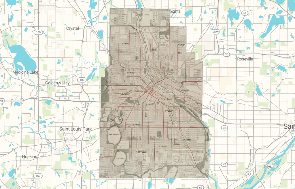
Before this, I had explored other digital map projects, but I mostly viewed them as an audience. I used to focus on how interactive features and rich details help tell a story or convey humanistic ideas, without considering the producer’s perspective of how an interactive map is built and presented. The “spatial turn” in digital humanities essentially uses new tools like GIS to address long-standing questions about land, power, and community. By placing historical maps and the modern world into the same coordinate system, we can ask questions such as “how has this place changed?” and “who decided those changes?” in entirely new ways.
In the export interface, my map can be shared via Allmaps Viewer, georeferenced annotations, XYZ map tiles, and GeoJSON links. This demonstrates the open reusability and interoperability of digital humanities. The georeferencing information is saved as independent annotation data separate from the image itself, allowing others to reuse, correct, or build upon my work.
With this georectified map, we could stack multiple layers of historical maps from different time periods to analyze changes in urban planning over time. We could track shifts in roads, rivers, coastlines, buildings, and land use. Alternatively, we could create an interactive online map exhibition of Minneapolis, using digital interaction to help the public better understand the history of Minnesota and Minneapolis.
However, there are several limitations. First, because historical and modern maps were drawn using different survey methods and map projections, alignment errors naturally occur. We often need to apply different transformation methods to fit the old map onto the new one. Second, maps are always drawn by specific people for specific purposes. For instance, the map I chose is specifically a political map. A single map of a city does not equal the city itself. Because every map has its own focus and biases, we cannot understand all of history through just one or two maps.
Finally, I don’t think this method works well for research questions that do not require precise spatial measurements. Mental maps or pictorial maps, and many Indigenous oral or performative spatial expressions, do not fit standard spatial grids. Forcing them into rigid coordinate systems risks misinterpreting what these spatial forms are actually trying to express.
It’s cool that you chose the map of 1913 Mandy! I definitely related when you mentioned how GIS and georeferencing made you think about aspects such as land and power. Those are things that have definitely changed over the course of 100+ years. I also chose a political map and it made me wonder what the intentions were of it. What do you think it was for?