For this project, I used AllMaps to georectify a historical map of Minneapolis, Minnesota. The map, titled City of Minneapolis, Minnesota, shows the city’s street layout and geographic features at an earlier point in its history. By aligning the historical map with a modern basemap, I was able to compare how the city was represented in the past with its present-day geography.
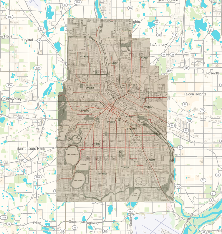
https://viewer.allmaps.org/?url=https://annotations.allmaps.org/images/476a6f6fa33885ee
Georectifying a historical map helped me understand how spatial digital humanities connect historical sources with modern geographic data. Using AllMaps made the process easy as well as more interactive because I could match locations on the historical map with locations on a modern basemap.
AllMaps provides several ways to access the georectified map, including the AllMaps Viewer, georeferencing annotation data, and XYZ map tiles. The Viewer makes the map easy to explore visually, while the annotation data preserves information about how the historical map was aligned with modern geography.
Georectification makes it possible to compare historical Minneapolis with the modern city and investigate changes in streets, neighborhoods, and geographic features. A potential next step would be to compare this map with other historical maps from different time periods to examine how the city expanded in sort of a “flip book” way where you saw each new map throughout time.
A problem with georeferencing is that it’s not perfectly accurate. Historical maps may contain distortions, outdated information, or inconsistent scales. The accuracy of the final map depends partly on the placement of control points. Incorrectly placed points can cause locations to become misaligned. Historical geography also changes over time, so streets, rivers, and neighborhood boundaries may no longer match their original locations.
Georectification is useful for studying where geographic features were located, but it is not appropriate for independently explaining why historical changes occurred. Therefore, I think georectification is most useful when combined with other historical evidence rather than treated as a complete explanation of the past.
Jack, I really enjoy the idea of using a variety of historical maps to produce a flipbook that illustrates how Minneapolis has changed over time. I think it’s very interesting method of showing the city’s growth. I agree with your statement regarding georeferencing not being entirely accurate. Sometimes, I found that even when I attempted to align some of the streets, the rest of the map was still a bit out of line.