Looking at the Hereford Mappa Mundi in 3D
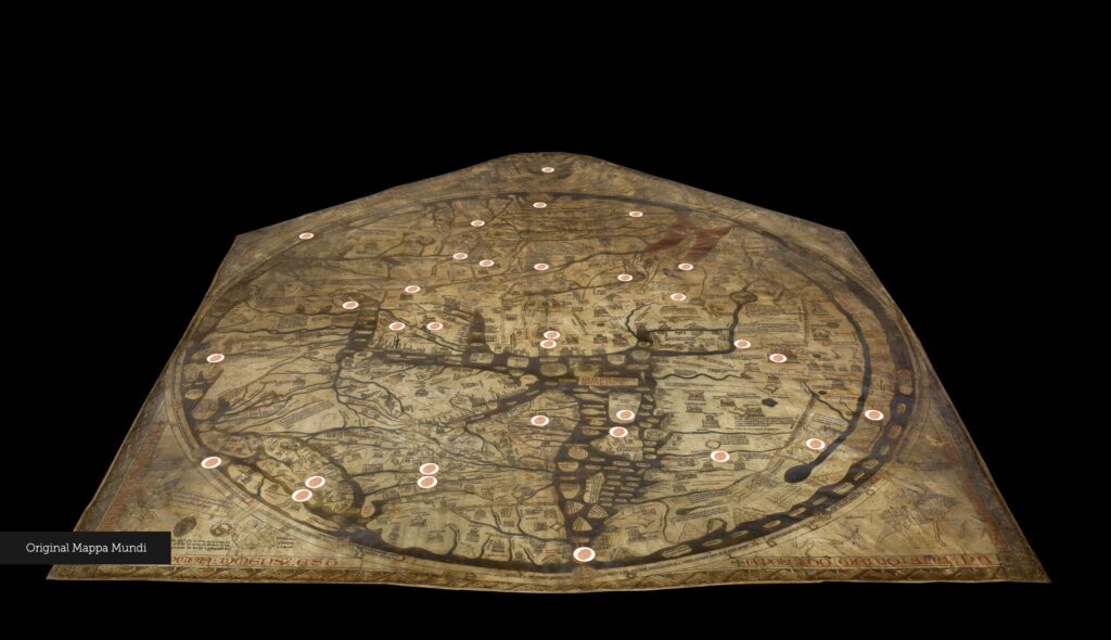
The Digital Humanities project I explored is the Hereford Mappa Mundi digital exploration. The Hereford Mappa Mundi is one of the most famous surviving medieval world maps, created around 1300 on a large sheet of vellum. This map combines cities, animals, biblical stories, mythology, and ideas about different peoples of the world. Jerusalem, for example, is placed at the center of the map, while the Garden of Eden appears at the top. The digital project allows users to move around the map and explore these details much more closely. Ther are three different layers of the map: users can also switch between the original map, a color-enhanced version, and a 3D scan of its surface.
Source
The source for this project is obviously the original Hereford Mappa Mundi itself. The map contains more than 500 drawings. The map was made on a single sheet of calfskin. The website also draws attention to details such as the tiny perforation at the center of Jerusalem that was probably produced by a compass and the flattening around Hereford that may have resulted from generations of visitors pointing at the location.
TECHNOLOGY
The process behind the project is probably the most interesting part. In 2013, the Mappa Mundi Trust commissioned Factum Arte to create the first high-resolution 3D scan of the map. This 3D model captured not only the overall shape of the vellum but also extremely small features such as wrinkles, scratches, patches, raised ink, and even differences in the thickness of pigments. I think this 3D model and its features remind us that digitization is something more than copying an object onto the computer.
PRESENTATION and QUESTION
The presentation brings all of these sources and processes together in a relatively simple interactive interface. Users can switch among the original image, color-enhanced image, and 3D scan. Markers divide information into categories such as Myths and Legends, Bible Stories, Beasts of the World, Strange Peoples of the World, and Towns and Cities. The 3D section goes even further by highlighting material features such as the tensions in the vellum. I think this is where the project works especially well as Digital Humanities. A traditional photograph is good at showing us what medieval people drew, but the 3D model allows us to investigate how the map was made and damaged. The digital presentation therefore adds another layer of historical questions rather than simply making an old map easier to view. This makes me wonder: How does our interpretation of a historical object change when we experience it as an original artifact, a digital 3D model, or a physical reproduction? I think this project can be applied not only in history or art history, but it can also be used as a tool for all humanities students to understand digitization.